
LIDAR and Mapping Historical Gold Mines
LIDAR and Mapping Historical Gold Mines
 If you are interested in obtaining LIDAR maps for your area please visit my website here: https://theprospectinggeologist.com/
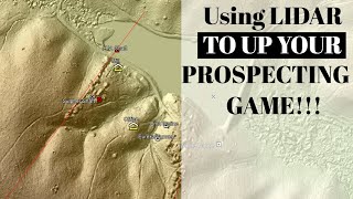
In this video I show how LIDAR can be used in correlation with old mining maps to make a modern map of old gold mines. The maps that can be created using this technique can increase your understanding of old gold mines tremendously as well as increase your potential of finding better gold around these old mines.
Please know that the two examples used in this video were used for academic purposes only and the property they currently lie on is all private. If you do not have permission to access DO NOT TRESPASS!!!
Here are other LIDAR gold mine related videos that I have done:
https://youtu.be/JvtEhfx6a78
OK Matt, another informative enlightening and fun session. My name is Robert I worked as a Geologist for a number of years here in my area. Our forte was “Preliminary Soil investigation” for the development of transportation Corredor‘s and communities. Here in Southern California.
My area was “field mapping,” “sample snatching,” and primarily and lots of “downhole login.” And then obviously all that information is passed on to the mappers. And engineers to decide how much of what had to be pulled out of where and what type of re-compaction, drainage, ect.
I’ve only in recent time decided to pick this back up as a hobby this mineral exploration. And I’m having a great time trying to solve the riddle of gold. Fascinating study, a lot of crockpots out there, but I do value the expertise and the time spent somebody like yourself… i’m not sure where I’m going with all of this right now, I’m thinking about joining American mining rights. And spending this coming summer just kind of traveling around and seeing what I can see. I’m hoping to look in Colorado Wyoming and Montana first. Any suggestions?
That’s totally cool
Great work Matt!
Interesting
You just teached me something I like a lot, thanks. Would love to learn more about map scouting
Another great video with great information.
Any California Lidar available yet? Thanks again. Great video
does it apply in the Yukon canada
What State are you in?
Great stuff, but your volume control is a bit sad.
Super la Californie ⛏👍
Anything for Arizona?
Boy outstanding….. You teach well, yet I have time understanding, but im going to get with a friend see if he could help, I can totally see benefits in purchasing some maps from you, you know you your poop. At any rate thank you
Hello 👋
Can I use my Android cell phone for the Lidar overlay