
Interactive 3D Maps of Mining Areas in Central City/Blackhawk, Colorado
Interactive 3D Maps of Mining Areas in Central City/Blackhawk, Colorado
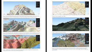 Easy to use interactive 3D maps to zoom-in, rotate, turn layers on/off, and more. This is an example 3D map created by 3D Geologic Mapping LLC which focuses on mining interests. If you’d like to try out our 3D maps and navigate them for yourself, just let us know! 303.479.4160, info@3dgeologicmapping.com.
Layers in this example include:
– Detailed geology, faults, dikes, veins, historic and active mines, aerial photo, historic topographic maps, mine claim info
– Roads, streams, lakes/ponds, public/private land map
– 3D symbols for campsites, town names, mines, drainage areas, mile-markers, historic mines, and more
– Also available – georeferenced 2D maps for field use – GPS location tracking (no cell phone signal needed)