
Dangerous McCormick Uranium Mine
Dangerous McCormick Uranium Mine
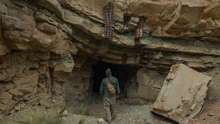 Recently I went out to Utah looking for some uranium mines. One that I was interested in finding was the McCormick mine. I wasn’t able to find any info on mining data sites but I remember seeing a picture of it and it seems very interesting with its steel bracing. In this video I find what I was looking for and I wasn’t disappointed.
Music by: The American Dollar
If your looking to buy some uranium ore check out uraniumstore.com
#radiation #radioactive #uranium
It’s possible that the infamous United States Radium Corporation used that mine to to gather carnotite for making their Luminous Radium Paint, they called them "Undark Mines".
Got to get better torches
Better be wearing some lead undies…
Which drone model are you using? Excellent panoramic shots.
خیلی عالی بود مرررردsded
What a spicy mine!
Dude you’re totally going to regret not seeing what else was in there! I have the same feeling when I leave a mine half explored
Awesome video!!
Would love to take my RadiaCode 101 Gamma spectrometer into that mine.
You aren’t worried about the radiation?
Shocking, I am from Fiji island, and would like to meet you in future!
Thanks.
The Canyon Country Zephyr has numerous articles about these mines that might interest anyone who wants to know the history of the uranium mining in this area. They can be accessed and read online.
Dude, thats really awesome ! Thanks for sharing that! i once went out to Arizona looking for a spot just south of Fredonia, I dont know if you ever heard about it but I was told there was very rich ore,
It sounds like there is a lot of radon in this mine and that is not good for your lungs… Anyway, great video from the exploration. I love the drone shots 😀
I was there a couple of years ago as well. I had the same feeling. Did not want to get buried alive. I left it to the bats. I did get a few specimens from the entrance. Great historical place to visit. I agree about the radon.
That is so cool! I would love to go find some Carnotite!
That is actually the Brunke Incline which was driven to access the uranium discovered on the Big Buck claims following the discovery of the Mi Vida mine on July 6, 1951. The McCormick mine is located to the south of this location beneath the ridge. It was operated by the Standard Uranium Company, and it exploited the same uranium ore bodies found in the Chinle formation that were originally discovered in 1951. The Mi Vida mine is located to the west of this incline. More than 26 million pounds of uranium was produced from the mines discovered in this area.
good work! I like your video.
and videos like this with names on the open mines is why the USGS goes an blasts them close an other rock hounds can never see them. you only have 388 subs an not much reach but edit this out
Why was there a torch behind you at 4:28? You said you were alone
Nicely done, m8. I lived in Utah all my life. Had no idea the wonder that was around!
you can actually see the gamma hitting the camera lens a few times
Those strips of iron that you talk about are called mats. The one at the portal with lots of holes is an aircraft landing mat. During the wars, they could hook them together and quickly make an airstrip with them. Back in the fifties, they were used in the mines to hold the ground up. The problem with them was, they were heavy and didn’t bend. The other mat could be bent to better secure the ground.
Hey. Get me some of that carnotite!